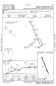
IAC chart of KGDB
 Satellite view of KGDB
Satellite view of KGDB
Sorry, we have no imagery here.
Sorry, we have no imagery here.
Sorry, we have no imagery here.
Sorry, we have no imagery here.
Sorry, we have no imagery here.
Sorry, we have no imagery here.


KGDB - Granite Falls Muni/Lenzen-Roe-Fagen Meml Fld
Located in Granite Falls, United States
ICAO - GDB, IATA -
Data provided by AirmateGeneral information
Coordinates: N44°45'9" W95°33'20"
Elevation is 1047 feet MSL.
Magnetic variation is 04° East View others Airports in Minnesota
Operational data
Special qualification required
Current time UTC:
Current local time:
Weather
METAR: KGDB 022155Z AUTO 31008KT 10SM BKN002 OVC012 02/01 A2933 RMK AO2 T00150013
Communications frequencies: [VIEW]
Runways:
| RWY identifier | QFU | Length (ft) | Width (ft) | Surface | LDA (ft) |
| 15 | 157° | 4357 | 75 | ASPH | |
| 33 | 337° | 4357 | 75 | ASPH |
Airport contact information
Address: Granite Falls United States
Satellite view of KGDB
Sorry, we have no imagery here.
Sorry, we have no imagery here.
Sorry, we have no imagery here.
Sorry, we have no imagery here.
Sorry, we have no imagery here.
Sorry, we have no imagery here.