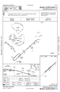
IAC chart of KGCY
 ADC chart of KGCY
 Satellite view of KGCY
ADC chart of KGCY
Satellite view of KGCY
Sorry, we have no imagery here.
Sorry, we have no imagery here.
Sorry, we have no imagery here.
Sorry, we have no imagery here.
Sorry, we have no imagery here.
Sorry, we have no imagery here.


KGCY - Greeneville Muni
Located in Greeneville, United States
ICAO - GCY, IATA - GCY
Data provided by AirmateGeneral information
Coordinates: N36°11'45" W82°48'41"
Elevation is 1607 feet MSL.
Magnetic variation is -07° East View others Airports in Tennessee
Operational data
Special qualification required
Current time UTC:
Current local time:
Weather
METAR: KGCY 080215Z AUTO 31004KT 10SM FEW022 BKN027 OVC075 08/05 A2983 RMK A01
Communications frequencies: [VIEW]
Runways:
| RWY identifier | QFU | Length (ft) | Width (ft) | Surface | LDA (ft) |
| 05 | 47° | 6300 | 100 | ASPH | |
| 23 | 227° | 6300 | 100 | ASPH |
Airport contact information
Address: Greeneville United States
Satellite view of KGCY
Sorry, we have no imagery here.
Sorry, we have no imagery here.
Sorry, we have no imagery here.
Sorry, we have no imagery here.
Sorry, we have no imagery here.
Sorry, we have no imagery here.