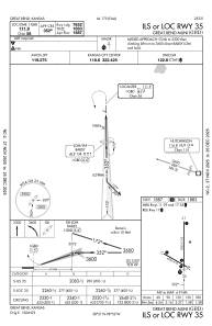
IAC chart of KGBD
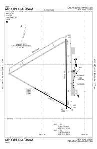
 ADC chart of KGBD
 Satellite view of KGBD
ADC chart of KGBD
Satellite view of KGBD
Sorry, we have no imagery here.
Sorry, we have no imagery here.
Sorry, we have no imagery here.
Sorry, we have no imagery here.
Sorry, we have no imagery here.
Sorry, we have no imagery here.


KGBD - Great Bend Muni
Located in Great Bend, United States
ICAO - GBD, IATA - GBD
Data provided by AirmateGeneral information
Coordinates: N38°20'39" W98°51'33"
Elevation is 1886 feet MSL.
Magnetic variation is 08° East View others Airports in Kansas
Operational data
Special qualification required
Current time UTC:
Current local time:
Weather
METAR: KGBD 120456Z AUTO 16011KT 10SM CLR 12/02 A3009 RMK AO2 SLP182 T01170022
TAF: KGBD 112322Z 1200/1224 16013KT P6SM SKC FM120900 17014G22KT P6SM SKC WS020/21050KT FM121500 19024G32KT P6SM SKC
Communications frequencies: [VIEW]
Runways:
| RWY identifier | QFU | Length (ft) | Width (ft) | Surface | LDA (ft) |
| 11 | 120° | 4706 | 75 | ASPH | 4706 |
| 29 | 300° | 4706 | 75 | ASPH | 4706 |
| 17 | 180° | 7852 | 100 | CONC | 7852 |
| 35 | 360° | 7852 | 100 | CONC | 7852 |
Airport contact information
Address: Great Bend United States
Other aviation service providers
Flight schools

Satellite view of KGBD
Sorry, we have no imagery here.
Sorry, we have no imagery here.
Sorry, we have no imagery here.
Sorry, we have no imagery here.
Sorry, we have no imagery here.
Sorry, we have no imagery here.