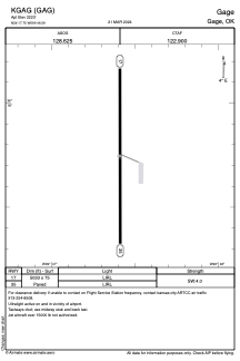
ADC chart of KGAG
 Satellite view of KGAG
Satellite view of KGAG
Sorry, we have no imagery here.
Sorry, we have no imagery here.
Sorry, we have no imagery here.
Sorry, we have no imagery here.
Sorry, we have no imagery here.


KGAG - Gage
Located in Gage, United States
ICAO - GAG, IATA - GAG
Data provided by AirmateGeneral information
Coordinates: N36°17'45" W99°46'35"
Elevation is 2223 feet MSL.
Magnetic variation is 08° East View others Airports in Oklahoma
Operational data
Special qualification required
Current time UTC:
Current local time:
Weather
METAR: KGAG 051118Z AUTO 36019G30KT 9SM -RA OVC009 02/01 A3019 RMK AO2 PK WND 36035/1106 CIG 006V012 P0001 T00220011
Communications frequencies: [VIEW]
Runways:
| RWY identifier | QFU | Length (ft) | Width (ft) | Surface | LDA (ft) |
| 17 | 180° | 5033 | 75 | ASPH | |
| 35 | 360° | 5033 | 75 | ASPH |
Airport contact information
Address: Gage United States
Satellite view of KGAG
Sorry, we have no imagery here.
Sorry, we have no imagery here.
Sorry, we have no imagery here.
Sorry, we have no imagery here.
Sorry, we have no imagery here.