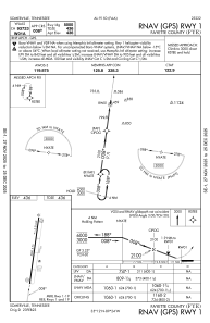
IAC chart of KFYE
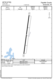
 ADC chart of KFYE
 Satellite view of KFYE
ADC chart of KFYE
Satellite view of KFYE
Sorry, we have no imagery here.
Sorry, we have no imagery here.
Sorry, we have no imagery here.
Sorry, we have no imagery here.
Sorry, we have no imagery here.
Sorry, we have no imagery here.


KFYE - Fayette County
Located in Somerville, United States
ICAO - FYE, IATA -
Data provided by AirmateGeneral information
Coordinates: N35°12'28" W89°23'40"
Elevation is 435 feet MSL.
Magnetic variation is 00° East View others Airports in Tennessee
Operational data
Special qualification required
Current time UTC:
Current local time:
Weather
METAR: KFYE 082115Z AUTO 33006G12KT 10SM CLR 12/M02 A3012 RMK A01
Communications frequencies: [VIEW]
Runways:
| RWY identifier | QFU | Length (ft) | Width (ft) | Surface | LDA (ft) |
| 01 | 8° | 5000 | 75 | ASPH | |
| 19 | 188° | 5000 | 75 | ASPH |
Airport contact information
Address: Somerville United States
Satellite view of KFYE
Sorry, we have no imagery here.
Sorry, we have no imagery here.
Sorry, we have no imagery here.
Sorry, we have no imagery here.
Sorry, we have no imagery here.
Sorry, we have no imagery here.