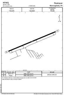
IAC chart of KFWQ
 ADC chart of KFWQ
 Satellite view of KFWQ
ADC chart of KFWQ
Satellite view of KFWQ
Sorry, we have no imagery here.
Sorry, we have no imagery here.
Sorry, we have no imagery here.
Sorry, we have no imagery here.
Sorry, we have no imagery here.
Sorry, we have no imagery here.


KFWQ - Rostraver
Located in Monongahela, United States
ICAO - FWQ, IATA -
Data provided by AirmateGeneral information
Coordinates: N40°12'35" W79°49'53"
Elevation is 1228 feet MSL.
Magnetic variation is -09° East View others Airports in Pennsylvania
Operational data
Special qualification required
Current time UTC:
Current local time:
Weather at : KAGC - Allegheny County ( 18 km )
METAR: KAGC 082053Z 32014G23KT 10SM FEW060 03/M12 A3002 RMK AO2 PK WND 28026/2007 SLP184 T00281117 53003
TAF: KAGC 081720Z 0818/0918 31015G25KT P6SM BKN040 FM082300 31011KT P6SM SCT050 FM090200 VRB04KT P6SM SKC FM091600 24007KT P6SM BKN200
Communications frequencies: [VIEW]
Runways:
| RWY identifier | QFU | Length (ft) | Width (ft) | Surface | LDA (ft) |
| 08 | 67° | 4002 | 75 | ASPH | |
| 26 | 247° | 4002 | 75 | ASPH |
Airport contact information
Address: Monongahela United States
Satellite view of KFWQ
Sorry, we have no imagery here.
Sorry, we have no imagery here.
Sorry, we have no imagery here.
Sorry, we have no imagery here.
Sorry, we have no imagery here.
Sorry, we have no imagery here.