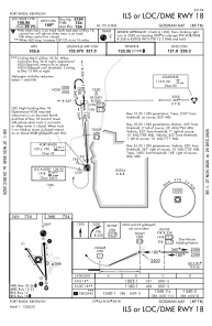
IAC chart of KFTK
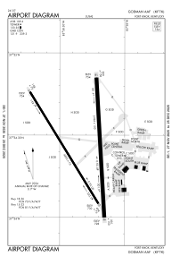
 ADC chart of KFTK
 Satellite view of KFTK
ADC chart of KFTK
Satellite view of KFTK
Sorry, we have no imagery here.
Sorry, we have no imagery here.
Sorry, we have no imagery here.
Sorry, we have no imagery here.
Sorry, we have no imagery here.
Sorry, we have no imagery here.


KFTK - Godman Aaf
Located in Fort Knox, United States
ICAO - FTK, IATA - FTK
Data provided by AirmateGeneral information
Coordinates: N37°54'25" W85°58'19"
Elevation is 754 feet MSL.
Magnetic variation is -03° East View others Airports in Kentucky
Operational data
Special qualification required
Current time UTC:
Current local time:
Weather
TAF: TAF KFTK 021100Z 0211/0317 15012G18KT 9999 SCT045 OVC250 WS020/18045KT QNH2976INS BECMG 0212/0213 17015G25KT 9999 BKN040 OVC200 510006 QNH2975INS BECMG 0216/0217 18025G35KT 9999 VCSH BKN035 OVC200 540009 QNH2970INS BECMG 0223/0224 17018G28KT 9999 VCTS BKN035CB OVC200 540009 QNH2970INS BECMG 0302/0303 20012G20KT 4800 RA BR VCTS BKN020CB OVC100 540009 QNH2970INS TEMPO 0305/0310 22030G45KT 1600 +TSRAGR OVC012CB BECMG 0309/0310 21009KT 9000 -SHRA VCTS BKN015CB OVC100 QNH2984INS TX27/0221Z TN15/0211Z
Communications frequencies: [VIEW]
Runways:
| RWY identifier | QFU | Length (ft) | Width (ft) | Surface | LDA (ft) |
| 15 | 0° | 4853 | 75 | ASPH | |
| 33 | 0° | 4853 | 75 | ASPH | |
| 18 | 0° | 5184 | 150 | ASPH | |
| 36 | 0° | 5184 | 150 | ASPH |
Airport contact information
Address: Fort Knox United States
Satellite view of KFTK
Sorry, we have no imagery here.
Sorry, we have no imagery here.
Sorry, we have no imagery here.
Sorry, we have no imagery here.
Sorry, we have no imagery here.
Sorry, we have no imagery here.