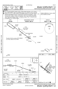
IAC chart of KFST
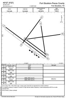
 ADC chart of KFST
 Satellite view of KFST
ADC chart of KFST
Satellite view of KFST
Sorry, we have no imagery here.
Sorry, we have no imagery here.
Sorry, we have no imagery here.
Sorry, we have no imagery here.
Sorry, we have no imagery here.
Sorry, we have no imagery here.


KFST - Fort Stockton-Pecos County
Located in Fort Stockton, United States
ICAO - FST, IATA - FST
Data provided by AirmateGeneral information
Coordinates: N30°54'55" W102°54'46"
Elevation is 3011 feet MSL.
Magnetic variation is 09° East View others Airports in Texas
Operational data
Special qualification required
Current time UTC:
Current local time:
Weather
METAR: KFST 012353Z AUTO 24012G20KT 10SM CLR 32/M11 A2951 RMK AO2 PK WND 25029/2313 SLP944 T03221111 10339 20294 58017 $
TAF: KFST 012358Z 0200/0224 25021G29KT P6SM SKC FM020200 23013KT P6SM FEW200 FM021300 29015KT P6SM SKC FM021700 22013KT P6SM FEW250
Communications frequencies: [VIEW]
Runways:
| RWY identifier | QFU | Length (ft) | Width (ft) | Surface | LDA (ft) |
| 03 | 37° | 4400 | 60 | ASPH | |
| 21 | 217° | 4400 | 60 | ASPH | |
| 07 | 82° | 4961 | 150 | GRASS | |
| 25 | 262° | 4961 | 150 | GRASS | |
| 11 | 126° | 3348 | 100 | GRASS | |
| 29 | 306° | 3348 | 100 | GRASS | |
| 12 | 127° | 7508 | 100 | ASPH | |
| 30 | 307° | 7508 | 100 | ASPH | |
| 16 | 171° | 3981 | 150 | GRASS | |
| 34 | 351° | 3981 | 150 | GRASS |
Airport contact information
Address: Fort Stockton United States
Satellite view of KFST
Sorry, we have no imagery here.
Sorry, we have no imagery here.
Sorry, we have no imagery here.
Sorry, we have no imagery here.
Sorry, we have no imagery here.
Sorry, we have no imagery here.