IAC chart of KFOT
 ADC chart of KFOT
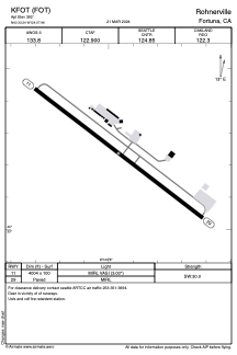
 Satellite view of KFOT
ADC chart of KFOT
Satellite view of KFOT
Sorry, we have no imagery here.
Sorry, we have no imagery here.
Sorry, we have no imagery here.
Sorry, we have no imagery here.
Sorry, we have no imagery here.
Sorry, we have no imagery here.


KFOT - Rohnerville
Located in Fortuna, United States
ICAO - FOT, IATA -
Data provided by AirmateGeneral information
Coordinates: N40°33'14" W124°7'58"
Elevation is 392 feet MSL.
Magnetic variation is 17° East View others Airports in California
Operational data
Special qualification required
Current time UTC:
Current local time:
Weather
METAR: KFOT 050855Z AUTO 13010G15KT 10SM FEW003 08/08 A3028 RMK AO1
Communications frequencies: [VIEW]
Runways:
| RWY identifier | QFU | Length (ft) | Width (ft) | Surface | LDA (ft) |
| 11 | 127° | 4004 | 100 | ASPH | |
| 29 | 307° | 4004 | 100 | ASPH |
Airport contact information
Address: Fortuna United States
Satellite view of KFOT
Sorry, we have no imagery here.
Sorry, we have no imagery here.
Sorry, we have no imagery here.
Sorry, we have no imagery here.
Sorry, we have no imagery here.
Sorry, we have no imagery here.