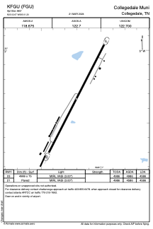
ADC chart of KFGU
 Satellite view of KFGU
Satellite view of KFGU
Sorry, we have no imagery here.
Sorry, we have no imagery here.
Sorry, we have no imagery here.
Sorry, we have no imagery here.
Sorry, we have no imagery here.
Sorry, we have no imagery here.


KFGU - Collegedale Muni
Located in Collegedale, United States
ICAO - FGU, IATA -
Data provided by AirmateGeneral information
Coordinates: N35°2'40" W85°1'12"
Elevation is 860 feet MSL.
Magnetic variation is -02° East View others Airports in Tennessee
Operational data
Special qualification required
Current time UTC:
Current local time:
Weather at : KCHA - Lovell Fld ( 17 km )
METAR: KCHA 081153Z 33005KT 10SM FEW025 FEW060 06/03 A3000 RMK AO2 SLP160 T00610033 10067 20050 53026
TAF: KCHA 081120Z 0812/0912 36003KT P6SM SKC FM081600 36009KT P6SM SKC FM090000 01004KT P6SM SKC
Communications frequencies: [VIEW]
Runways:
| RWY identifier | QFU | Length (ft) | Width (ft) | Surface | LDA (ft) |
| 03 | 0° | 4986 | 75 | ASPH | 4586 |
| 21 | 0° | 4986 | 75 | ASPH | 4586 |
Airport contact information
Address: Collegedale United States
Other aviation service providers
Flight schools

Satellite view of KFGU
Sorry, we have no imagery here.
Sorry, we have no imagery here.
Sorry, we have no imagery here.
Sorry, we have no imagery here.
Sorry, we have no imagery here.
Sorry, we have no imagery here.