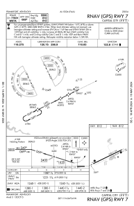
IAC chart of KFFT
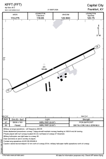
 ADC chart of KFFT
 Satellite view of KFFT

ADC chart of KFFT
Satellite view of KFFT
Sorry, we have no imagery here.
Sorry, we have no imagery here.
Sorry, we have no imagery here.
Sorry, we have no imagery here.
Sorry, we have no imagery here.
Sorry, we have no imagery here.


KFFT - Capital City
Located in Frankfort, United States
ICAO - FFT, IATA - FFT
Data provided by AirmateGeneral information
Coordinates: N38°10'54" W84°54'24"
Elevation is 812 feet MSL.
Magnetic variation is -05° East View others Airports in Kentucky
Operational data
Special qualification required
Current time UTC:
Current local time:
Weather
METAR: KFFT 020153Z AUTO 08007KT 10SM CLR 09/03 A3003 RMK AO2 SLP172 T00940033
Communications frequencies: [VIEW]
Runways:
| RWY identifier | QFU | Length (ft) | Width (ft) | Surface | LDA (ft) |
| 07 | 64° | 5506 | 100 | ASPH | |
| 25 | 244° | 5506 | 100 | ASPH |
Airport contact information
Address: Frankfort United States
Other aviation service providers
Flight schools

Satellite view of KFFT
Sorry, we have no imagery here.
Sorry, we have no imagery here.
Sorry, we have no imagery here.
Sorry, we have no imagery here.
Sorry, we have no imagery here.
Sorry, we have no imagery here.