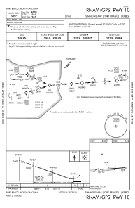
IAC chart of KFBG
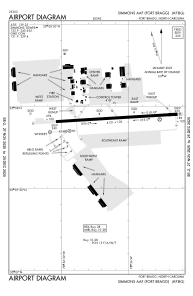
 ADC chart of KFBG
 Satellite view of KFBG
ADC chart of KFBG
Satellite view of KFBG
Sorry, we have no imagery here.
Sorry, we have no imagery here.
Sorry, we have no imagery here.
Sorry, we have no imagery here.
Sorry, we have no imagery here.
Sorry, we have no imagery here.


KFBG - Simmons Aaf
Located in Fort Liberty, United States
ICAO - FBG, IATA - FBG
Data provided by AirmateGeneral information
Coordinates: N35°7'56" W78°56'7"
Elevation is 243 feet MSL.
Magnetic variation is -07° East View others Airports in North Carolina
Operational data
Special qualification required
Current time UTC:
Current local time:
Weather
METAR: KFBG 021255Z AUTO 09008KT 10SM SCT023 BKN031 15/09 A3028 RMK AO2 SLP256 T01450093 RVRNO $
TAF: TAF AMD KFBG 021044Z 0210/0315 08006KT 9000 BR OVC020 QNH3023INS BECMG 0215/0216 12010G15KT 9999 NSW OVC020 QNH3020INS BECMG 0223/0224 12006KT 8000 BR SCT008 BKN020 OVC025 QNH3021INS BECMG 0302/0303 14009KT 8000 BR OVC006 QNH3018INS BECMG 0314/0315 19010G15KT 8000 BR SCT020 QNH3026INS TX23/0219Z TN11/0212Z
Communications frequencies: [VIEW]
Runways:
| RWY identifier | QFU | Length (ft) | Width (ft) | Surface | LDA (ft) |
| 09 | 86° | 4121 | 100 | ASPH | |
| 27 | 266° | 4121 | 100 | ASPH |
Airport contact information
Address: Fort Liberty United States
Satellite view of KFBG
Sorry, we have no imagery here.
Sorry, we have no imagery here.
Sorry, we have no imagery here.
Sorry, we have no imagery here.
Sorry, we have no imagery here.
Sorry, we have no imagery here.