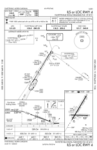
IAC chart of KFAY
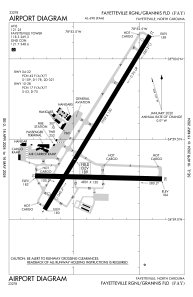
 ADC chart of KFAY
 Satellite view of KFAY
ADC chart of KFAY
Satellite view of KFAY
Sorry, we have no imagery here.
Sorry, we have no imagery here.
Sorry, we have no imagery here.
Sorry, we have no imagery here.
Sorry, we have no imagery here.
Sorry, we have no imagery here.


KFAY - Fayetteville Rgnl/Grannis Fld
Located in Fayetteville, United States
ICAO - FAY, IATA - FAY
Data provided by AirmateGeneral information
Coordinates: N34°59'28" W78°52'49"
Elevation is 189 feet MSL.
Magnetic variation is -07° East View others Airports in North Carolina
Operational data
Special qualification required
Current time UTC:
Current local time:
Weather
METAR: KFAY 020653Z 08007KT 10SM FEW010 OVC016 14/12 A3020 RMK AO2 SLP222 T01390117
TAF: KFAY 020600Z 0206/0306 09006KT P6SM SCT008 BKN012 TEMPO 0206/0208 BKN008 FM021500 10008G15KT P6SM BKN025 BKN250 FM021800 14010G18KT P6SM BKN035 FM030300 16009KT P6SM OVC007
Communications frequencies: [VIEW]
Runways:
| RWY identifier | QFU | Length (ft) | Width (ft) | Surface | LDA (ft) |
| 04 | 31° | 7709 | 150 | ASPH | 6508 |
| 22 | 211° | 7709 | 150 | ASPH | 6413 |
| 10 | 91° | 4801 | 150 | ASPH | |
| 28 | 271° | 4801 | 150 | ASPH |
Airport contact information
Address: Fayetteville United States
Other aviation service providers
Repair station

Flight schools

All American Aviation Services, Llc
All American Aviation Services, Llc
allamericanaviationservices@gmail.com+1(910)644-8817
Fayetteville Technical Community College
Fayetteville Technical Community College
ceonline@faytechcc.edu+1(910)678-8431
Satellite view of KFAY
Sorry, we have no imagery here.
Sorry, we have no imagery here.
Sorry, we have no imagery here.
Sorry, we have no imagery here.
Sorry, we have no imagery here.
Sorry, we have no imagery here.