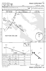
IAC chart of KFAF
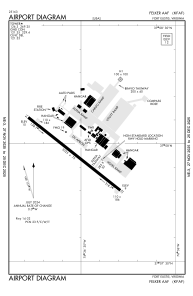
 ADC chart of KFAF
 Satellite view of KFAF
ADC chart of KFAF
Satellite view of KFAF
Sorry, we have no imagery here.
Sorry, we have no imagery here.
Sorry, we have no imagery here.
Sorry, we have no imagery here.
Sorry, we have no imagery here.
Sorry, we have no imagery here.


KFAF - Felker Aaf
Located in Fort Eustis, United States
ICAO - FAF, IATA - FAF
Data provided by AirmateGeneral information
Coordinates: N37°7'57" W76°36'32"
Elevation is 11 feet MSL.
Magnetic variation is -11° East View others Airports in Virginia
Operational data
Special qualification required
Current time UTC:
Current local time:
Weather
METAR: KFAF 011455Z 33009KT 10SM FEW060 13/03 A2999 RMK AO2A SLP159 T01270031 52032 $
TAF: TAF AMD KFAF 011515Z 0115/0216 35008KT 9999 FEW250 QNH3000INS BECMG 0214/0215 11010KT 9999 SCT250 QNH3032INS TX16/0120Z TN07/0209Z LAST NO AMDS AFT 0115 NEXT 0210
Communications frequencies: [VIEW]
Runways:
| RWY identifier | QFU | Length (ft) | Width (ft) | Surface | LDA (ft) |
| 14 | 128° | 3025 | 75 | ASPH | |
| 32 | 308° | 3025 | 75 | ASPH | |
| H1 | 0° | 0 | 0 | UNK |
Airport contact information
Address: Fort Eustis United States
Satellite view of KFAF
Sorry, we have no imagery here.
Sorry, we have no imagery here.
Sorry, we have no imagery here.
Sorry, we have no imagery here.
Sorry, we have no imagery here.
Sorry, we have no imagery here.