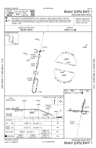
IAC chart of KEZI
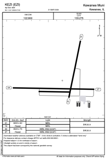
 ADC chart of KEZI
 Satellite view of KEZI
ADC chart of KEZI
Satellite view of KEZI
Sorry, we have no imagery here.
Sorry, we have no imagery here.
Sorry, we have no imagery here.
Sorry, we have no imagery here.
Sorry, we have no imagery here.
Sorry, we have no imagery here.


KEZI - Kewanee Muni
Located in Kewanee, United States
ICAO - EZI, IATA -
Data provided by AirmateGeneral information
Coordinates: N41°12'19" W89°57'50"
Elevation is 858 feet MSL.
Magnetic variation is -02° East View others Airports in Illinois
Operational data
Special qualification required
Current time UTC:
Current local time:
Weather at : KGBG - Galesburg Muni ( 49 km )
METAR: KGBG 081235Z AUTO 00000KT 10SM CLR M03/M06 A3023 RMK AO2 T10321058
Communications frequencies: [VIEW]
Runways:
| RWY identifier | QFU | Length (ft) | Width (ft) | Surface | LDA (ft) |
| 01 | 11° | 3200 | 60 | ASPH | |
| 19 | 191° | 3200 | 60 | ASPH | |
| 09 | 91° | 4500 | 75 | ASPH | |
| 27 | 271° | 4500 | 75 | ASPH |
Airport contact information
Address: Kewanee United States
Other aviation service providers
Flight schools

Satellite view of KEZI
Sorry, we have no imagery here.
Sorry, we have no imagery here.
Sorry, we have no imagery here.
Sorry, we have no imagery here.
Sorry, we have no imagery here.
Sorry, we have no imagery here.