IAC chart of KEXX
 ADC chart of KEXX
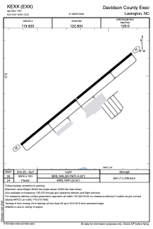
 Satellite view of KEXX
ADC chart of KEXX
Satellite view of KEXX
Sorry, we have no imagery here.
Sorry, we have no imagery here.
Sorry, we have no imagery here.
Sorry, we have no imagery here.
Sorry, we have no imagery here.
Sorry, we have no imagery here.


KEXX - Davidson County Exec
Located in Lexington, United States
ICAO - EXX, IATA -
Data provided by AirmateGeneral information
Coordinates: N35°46'52" W80°18'14"
Elevation is 732 feet MSL.
Magnetic variation is -07° East View others Airports in North Carolina
Operational data
Special qualification required
Current time UTC:
Current local time:
Weather
METAR: KEXX 020845Z AUTO 11004KT 10SM OVC009 12/10 A3020 RMK AO2 T01180097
Communications frequencies: [VIEW]
Runways:
| RWY identifier | QFU | Length (ft) | Width (ft) | Surface | LDA (ft) |
| 06 | 51° | 5004 | 100 | ASPH | |
| 24 | 231° | 5004 | 100 | ASPH |
Airport contact information
Address: Lexington United States
Other aviation service providers
Flight schools

Satellite view of KEXX
Sorry, we have no imagery here.
Sorry, we have no imagery here.
Sorry, we have no imagery here.
Sorry, we have no imagery here.
Sorry, we have no imagery here.
Sorry, we have no imagery here.