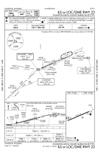
IAC chart of KEVW
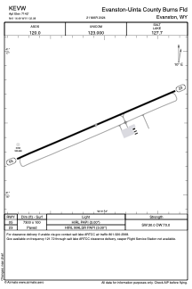
 ADC chart of KEVW
 Satellite view of KEVW
ADC chart of KEVW
Satellite view of KEVW
Sorry, we have no imagery here.
Sorry, we have no imagery here.
Sorry, we have no imagery here.
Sorry, we have no imagery here.
Sorry, we have no imagery here.
Sorry, we have no imagery here.


KEVW - Evanston-Uinta County Burns Fld
Located in Evanston, United States
ICAO - EVW, IATA - EVW
Data provided by AirmateGeneral information
Coordinates: N41°16'29" W111°2'5"
Elevation is 7142 feet MSL.
Magnetic variation is 13° East View others Airports in Wyoming
Operational data
Special qualification required
Current time UTC:
Current local time:
Weather
METAR: KEVW 081453Z AUTO 25008KT 10SM CLR 08/M06 A3009 RMK AO2 SLP137 T00831056 52014
TAF: KEVW 081120Z 0812/0912 24010KT P6SM SCT060 BKN150 FM081800 26018G28KT P6SM SCT060 BKN120 FM090200 25009KT P6SM BKN120
Communications frequencies: [VIEW]
Runways:
| RWY identifier | QFU | Length (ft) | Width (ft) | Surface | LDA (ft) |
| 05 | 66° | 7300 | 100 | ASPH | |
| 23 | 246° | 7300 | 100 | ASPH |
Airport contact information
Address: Evanston United States
Other aviation service providers
Flight schools

Satellite view of KEVW
Sorry, we have no imagery here.
Sorry, we have no imagery here.
Sorry, we have no imagery here.
Sorry, we have no imagery here.
Sorry, we have no imagery here.
Sorry, we have no imagery here.