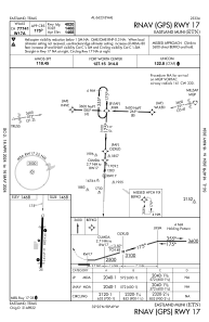
IAC chart of KETN
 Satellite view of KETN
Satellite view of KETN
Sorry, we have no imagery here.
Sorry, we have no imagery here.
Sorry, we have no imagery here.
Sorry, we have no imagery here.
Sorry, we have no imagery here.


KETN - Eastland Muni
Located in Eastland, United States
ICAO - ETN, IATA - ETN
Data provided by AirmateGeneral information
Coordinates: N32°24'54" W98°48'35"
Elevation is 1467 feet MSL.
Magnetic variation is 07° East View others Airports in Texas
Operational data
Special qualification required
Current time UTC:
Current local time:
Weather
METAR: KETN 021435Z AUTO 33011G17KT 10SM CLR 20/01 A2964 RMK AO2 T02020009
Communications frequencies: [VIEW]
Runways:
| RWY identifier | QFU | Length (ft) | Width (ft) | Surface | LDA (ft) |
| 17 | 182° | 5000 | 60 | ASPH | |
| 35 | 2° | 5000 | 60 | ASPH |
Airport contact information
Address: Eastland United States
Satellite view of KETN
Sorry, we have no imagery here.
Sorry, we have no imagery here.
Sorry, we have no imagery here.
Sorry, we have no imagery here.
Sorry, we have no imagery here.