ADC chart of KESW
 Satellite view of KESW
Satellite view of KESW
Sorry, we have no imagery here.
Sorry, we have no imagery here.
Sorry, we have no imagery here.
Sorry, we have no imagery here.
Sorry, we have no imagery here.
Sorry, we have no imagery here.


KESW - Easton State
Located in Easton, United States
ICAO - ESW, IATA - ESW
Data provided by AirmateGeneral information
Coordinates: N47°15'15" W121°11'8"
Elevation is 2226 feet MSL.
Magnetic variation is 20° East View others Airports in Washington
Operational data
Special qualification required
Current time UTC:
Current local time:
Weather at : KELN - Bowers Fld ( 55 km )
METAR: KELN 050753Z AUTO 03003KT 10SM CLR 04/M03 A3037 RMK AO2 SLP291 T00391028 401611022
Communications frequencies: [VIEW]
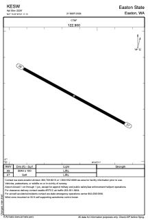
Runways:
| RWY identifier | QFU | Length (ft) | Width (ft) | Surface | LDA (ft) |
| 09 | 118° | 2640 | 100 | GRASS | |
| 27 | 298° | 2640 | 100 | GRASS |
Airport contact information
Address: Easton United States
Satellite view of KESW
Sorry, we have no imagery here.
Sorry, we have no imagery here.
Sorry, we have no imagery here.
Sorry, we have no imagery here.
Sorry, we have no imagery here.
Sorry, we have no imagery here.