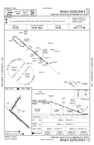
IAC chart of KERV
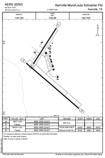
 ADC chart of KERV
 Satellite view of KERV
ADC chart of KERV
Satellite view of KERV
Sorry, we have no imagery here.
Sorry, we have no imagery here.
Sorry, we have no imagery here.
Sorry, we have no imagery here.
Sorry, we have no imagery here.
Sorry, we have no imagery here.


KERV - Kerrville Muni/Louis Schreiner Fld
Located in Kerrville, United States
ICAO - ERV, IATA - ERV
Data provided by AirmateGeneral information
Coordinates: N29°58'36" W99°5'8"
Elevation is 1616 feet MSL.
Magnetic variation is 06° East View others Airports in Texas
Operational data
Special qualification required
Current time UTC:
Current local time:
Weather
METAR: KERV 020515Z AUTO 15011G19KT 7SM OVC014 23/21 A2959 RMK AO2 T02330205
Communications frequencies: [VIEW]
Runways:
| RWY identifier | QFU | Length (ft) | Width (ft) | Surface | LDA (ft) |
| 03 | 33° | 3597 | 58 | ASPH | |
| 21 | 213° | 3597 | 58 | ASPH | |
| 12 | 131° | 6004 | 100 | ASPH | 5313 |
| 30 | 311° | 6004 | 100 | ASPH | 5300 |
Airport contact information
Address: Kerrville United States
Other aviation service providers
Flight schools

Satellite view of KERV
Sorry, we have no imagery here.
Sorry, we have no imagery here.
Sorry, we have no imagery here.
Sorry, we have no imagery here.
Sorry, we have no imagery here.
Sorry, we have no imagery here.