IAC chart of KERI
ADC chart of KERI
Satellite view of KERI
Sorry, we have no imagery here.
To navigate, press the arrow keys.
KERI - Erie Intl/Tom Ridge Fld
Located in Erie, United States
ICAO - ERI, IATA - ERI
Data provided by
Airmate
General information
Coordinates:
N42°4'59" W80°10'26"
Elevation is
732 feet MSL.
Magnetic variation is
-10° East
Add your vote
Valid your vote
View others
Airports in
Pennsylvania
Operational data
Special qualification required
Current time UTC:
Current local time:
View NOTAMs / SUP AIP / TFR affecting this airport
[VIEW]
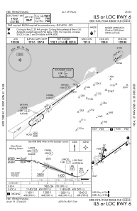
Communications frequencies:
[VIEW]
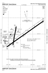
Runways:
RWY identifier
QFU
Length
(ft)
Width
(ft)
Surface
LDA
(ft)
02
10°
3508
150
ASPH
2520
20
190°
3508
150
ASPH
2902
06
54°
8420
150
ASPH
7501
24
234°
8420
150
ASPH
7500
Airport contact information
Address:
Erie United States
Other aviation service providers
Flight schools
WEB
North Coast Flight School, Inc.
gshncfs@yahoo.com
+1(814)434-0875
Add your vote
Valid your vote
Satellite view of KERI
Sorry, we have no imagery here.
To navigate, press the arrow keys.
<<
BESbswy
BESbswy