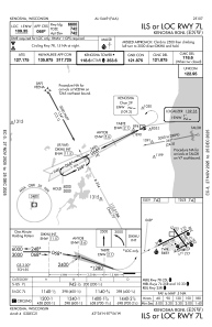
IAC chart of KENW
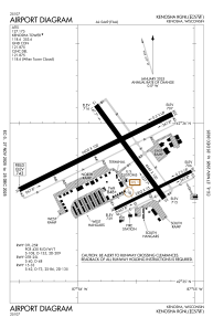
 ADC chart of KENW
 Satellite view of KENW
ADC chart of KENW
Satellite view of KENW
Sorry, we have no imagery here.
Sorry, we have no imagery here.
Sorry, we have no imagery here.
Sorry, we have no imagery here.
Sorry, we have no imagery here.
Sorry, we have no imagery here.


KENW - Kenosha Rgnl
Located in Kenosha, United States
ICAO - ENW, IATA - ENW
Data provided by AirmateGeneral information
Coordinates: N42°35'46" W87°55'38"
Elevation is 742 feet MSL.
Magnetic variation is -02° East View others Airports in Wisconsin
Operational data
Special qualification required
Current time UTC:
Current local time:
Weather
METAR: KENW 250953Z AUTO 05003KT 10SM OVC085 11/07 A3028 RMK AO2 SLP254 T01060067
TAF: KENW 250909Z 2509/2606 00000KT P6SM OVC080 FM251300 06005KT P6SM SCT150 FM251700 07007KT P6SM SCT060 FM260100 VRB04KT P6SM FEW250
Communications frequencies: [VIEW]
Runways:
| RWY identifier | QFU | Length (ft) | Width (ft) | Surface | LDA (ft) |
| 07L | 64° | 6600 | 100 | CONC | |
| 25R | 244° | 6600 | 100 | CONC | |
| 07R | 64° | 3302 | 75 | OTHER | |
| 25L | 244° | 3302 | 75 | OTHER | |
| 15 | 144° | 4440 | 100 | CONC | |
| 33 | 324° | 4440 | 100 | CONC |
Airport contact information
Address: Kenosha United States
Other aviation service providers
Flight schools

Satellite view of KENW
Sorry, we have no imagery here.
Sorry, we have no imagery here.
Sorry, we have no imagery here.
Sorry, we have no imagery here.
Sorry, we have no imagery here.
Sorry, we have no imagery here.