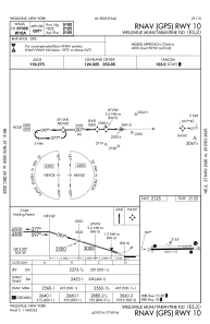
IAC chart of KELZ
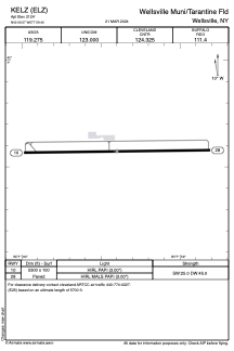
 ADC chart of KELZ
 Satellite view of KELZ
ADC chart of KELZ
Satellite view of KELZ
Sorry, we have no imagery here.
Sorry, we have no imagery here.
Sorry, we have no imagery here.
Sorry, we have no imagery here.
Sorry, we have no imagery here.
Sorry, we have no imagery here.


KELZ - Wellsville Muni/Tarantine Fld
Located in Wellsville, United States
ICAO - ELZ, IATA - ELZ
Data provided by AirmateGeneral information
Coordinates: N42°6'34" W77°59'24"
Elevation is 2124 feet MSL.
Magnetic variation is -08° East View others Airports in New York
Operational data
Special qualification required
Current time UTC:
Current local time:
Weather
METAR: KELZ 081156Z AUTO 29022G33KT 9SM -SN OVC025 M07/M11 A2972 RMK AO2 PK WND 29038/1125 SLP085 P0000 60000 70007 T10671111 11056 21072 53013 $
Communications frequencies: [VIEW]
Runways:
| RWY identifier | QFU | Length (ft) | Width (ft) | Surface | LDA (ft) |
| 10 | 89° | 5300 | 100 | ASPH | |
| 28 | 269° | 5300 | 100 | ASPH |
Airport contact information
Address: Wellsville United States
Satellite view of KELZ
Sorry, we have no imagery here.
Sorry, we have no imagery here.
Sorry, we have no imagery here.
Sorry, we have no imagery here.
Sorry, we have no imagery here.
Sorry, we have no imagery here.