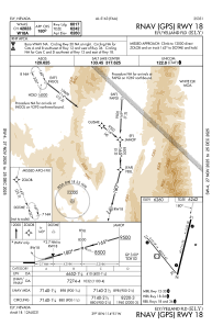
IAC chart of KELY
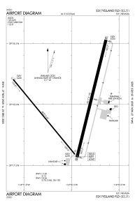
 ADC chart of KELY
 Satellite view of KELY
ADC chart of KELY
Satellite view of KELY
Sorry, we have no imagery here.
Sorry, we have no imagery here.
Sorry, we have no imagery here.
Sorry, we have no imagery here.
Sorry, we have no imagery here.
Sorry, we have no imagery here.


KELY - Ely/Yelland Fld
Located in Ely, United States
ICAO - ELY, IATA - ELY
Data provided by AirmateGeneral information
Coordinates: N39°17'59" W114°50'31"
Elevation is 6259 feet MSL.
Magnetic variation is 14° East View others Airports in Nevada
Operational data
Special qualification required
Current time UTC:
Current local time:
Weather
METAR: KELY 050753Z AUTO 00000KT 10SM CLR M03/M10 A3030 RMK AO2 SLP257 T10281100 400721094
TAF: KELY 050520Z 0506/0606 36008KT P6SM SKC FM051700 01010G20KT P6SM SKC FM060000 01008KT P6SM SCT200
Communications frequencies: [VIEW]
Runways:
| RWY identifier | QFU | Length (ft) | Width (ft) | Surface | LDA (ft) |
| 12 | 141° | 4825 | 60 | ASPH | |
| 30 | 321° | 4825 | 60 | ASPH | |
| 18 | 194° | 6017 | 150 | ASPH | |
| 36 | 14° | 6017 | 150 | ASPH |
Airport contact information
Address: Ely United States
Satellite view of KELY
Sorry, we have no imagery here.
Sorry, we have no imagery here.
Sorry, we have no imagery here.
Sorry, we have no imagery here.
Sorry, we have no imagery here.
Sorry, we have no imagery here.