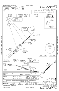
IAC chart of KEKX
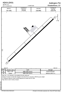
 ADC chart of KEKX
 Satellite view of KEKX
ADC chart of KEKX
Satellite view of KEKX
Sorry, we have no imagery here.
Sorry, we have no imagery here.
Sorry, we have no imagery here.
Sorry, we have no imagery here.
Sorry, we have no imagery here.
Sorry, we have no imagery here.


KEKX - Addington Fld
Located in Elizabethtown, United States
ICAO - EKX, IATA - EKX
Data provided by AirmateGeneral information
Coordinates: N37°41'10" W85°55'30"
Elevation is 775 feet MSL.
Magnetic variation is -03° East View others Airports in Kentucky
Operational data
Special qualification required
Current time UTC:
Current local time:
Weather
METAR: KEKX 020655Z AUTO 14005KT 10SM SCT050 10/04 A2990 RMK AO2 T00990039
Communications frequencies: [VIEW]
Runways:
| RWY identifier | QFU | Length (ft) | Width (ft) | Surface | LDA (ft) |
| 05 | 47° | 6001 | 100 | ASPH | |
| 23 | 227° | 6001 | 100 | ASPH |
Airport contact information
Address: Elizabethtown United States

Satellite view of KEKX
Sorry, we have no imagery here.
Sorry, we have no imagery here.
Sorry, we have no imagery here.
Sorry, we have no imagery here.
Sorry, we have no imagery here.
Sorry, we have no imagery here.