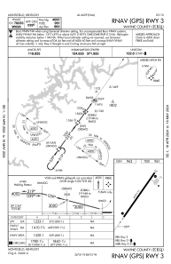
IAC chart of KEKQ
 ADC chart of KEKQ
 Satellite view of KEKQ
ADC chart of KEKQ
Satellite view of KEKQ
Sorry, we have no imagery here.
Sorry, we have no imagery here.
Sorry, we have no imagery here.
Sorry, we have no imagery here.
Sorry, we have no imagery here.
Sorry, we have no imagery here.


KEKQ - Wayne County
Located in Monticello, United States
ICAO - EKQ, IATA -
Data provided by AirmateGeneral information
Coordinates: N36°51'19" W84°51'22"
Elevation is 962 feet MSL.
Magnetic variation is -03° East View others Airports in Kentucky
Operational data
Special qualification required
Current time UTC:
Current local time:
Weather
METAR: KEKQ 021256Z AUTO 18015G21KT 10SM CLR 19/10 A2992 RMK AO2 SLP123 T01890100
Communications frequencies: [VIEW]
Runways:
| RWY identifier | QFU | Length (ft) | Width (ft) | Surface | LDA (ft) |
| 03 | 36° | 4000 | 75 | ASPH | |
| 21 | 216° | 4000 | 75 | ASPH |
Airport contact information
Address: Monticello United States
Satellite view of KEKQ
Sorry, we have no imagery here.
Sorry, we have no imagery here.
Sorry, we have no imagery here.
Sorry, we have no imagery here.
Sorry, we have no imagery here.
Sorry, we have no imagery here.