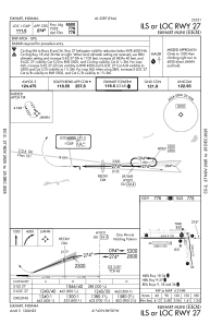
IAC chart of KEKM
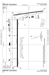
 ADC chart of KEKM
 Satellite view of KEKM
ADC chart of KEKM
Satellite view of KEKM
Sorry, we have no imagery here.
Sorry, we have no imagery here.
Sorry, we have no imagery here.
Sorry, we have no imagery here.
Sorry, we have no imagery here.
Sorry, we have no imagery here.


KEKM - Elkhart Muni
Located in Elkhart, United States
ICAO - EKM, IATA - EKI
Data provided by AirmateGeneral information
Coordinates: N41°43'10" W86°0'12"
Elevation is 777 feet MSL.
Magnetic variation is -04° East View others Airports in Indiana
Operational data
Special qualification required
Current time UTC:
Current local time:
Weather
METAR: KEKM 051235Z AUTO 01005KT 10SM OVC007 06/06 A2995 RMK AO2 CIG 006V008 T00610061 $
Communications frequencies: [VIEW]
Runways:
| RWY identifier | QFU | Length (ft) | Width (ft) | Surface | LDA (ft) |
| 08 | 89° | 2480 | 250 | GRASS | 2480 |
| 26 | 269° | 2480 | 250 | GRASS | 2480 |
| 09 | 90° | 6500 | 120 | CONC | 6500 |
| 27 | 270° | 6500 | 120 | CONC | 6500 |
| 18 | 172° | 3999 | 75 | ASPH | 4001 |
| 36 | 352° | 3999 | 75 | ASPH | 4001 |
Airport contact information
Address: Elkhart United States
Satellite view of KEKM
Sorry, we have no imagery here.
Sorry, we have no imagery here.
Sorry, we have no imagery here.
Sorry, we have no imagery here.
Sorry, we have no imagery here.
Sorry, we have no imagery here.