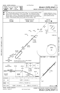
IAC chart of KEHO
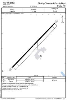
 ADC chart of KEHO
 Satellite view of KEHO
ADC chart of KEHO
Satellite view of KEHO
Sorry, we have no imagery here.
Sorry, we have no imagery here.
Sorry, we have no imagery here.
Sorry, we have no imagery here.
Sorry, we have no imagery here.
Sorry, we have no imagery here.


KEHO - Shelby-Cleveland County Rgnl
Located in Shelby, United States
ICAO - EHO, IATA -
Data provided by AirmateGeneral information
Coordinates: N35°15'21" W81°36'3"
Elevation is 846 feet MSL.
Magnetic variation is -06° East View others Airports in North Carolina
Operational data
Special qualification required
Current time UTC:
Current local time:
Weather
METAR: KEHO 020510Z AUTO 00000KT 10SM CLR 11/08 A3015 RMK AO2 T01100078
Communications frequencies: [VIEW]
Runways:
| RWY identifier | QFU | Length (ft) | Width (ft) | Surface | LDA (ft) |
| 05 | 44° | 5001 | 100 | ASPH | |
| 23 | 224° | 5001 | 100 | ASPH |
Airport contact information
Address: Shelby United States
Other aviation service providers
Flight schools

Satellite view of KEHO
Sorry, we have no imagery here.
Sorry, we have no imagery here.
Sorry, we have no imagery here.
Sorry, we have no imagery here.
Sorry, we have no imagery here.
Sorry, we have no imagery here.