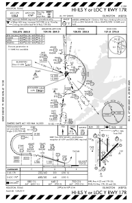
IAC chart of KEFD
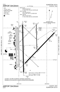
 ADC chart of KEFD
 Satellite view of KEFD
ADC chart of KEFD
Satellite view of KEFD
Sorry, we have no imagery here.
Sorry, we have no imagery here.
Sorry, we have no imagery here.
Sorry, we have no imagery here.
Sorry, we have no imagery here.
Sorry, we have no imagery here.


KEFD - Ellington
Located in Houston, United States
ICAO - EFD, IATA - EFD
Data provided by AirmateGeneral information
Coordinates: N29°36'26" W95°9'32"
Elevation is 32 feet MSL.
Magnetic variation is 05° East View others Airports in Texas
Operational data
Special qualification required
Current time UTC:
Current local time:
Weather
METAR: KEFD 020054Z 14011G18KT 10SM FEW020 BKN026 24/21 A2968
TAF: TAF KEFD 012000Z 0120/0302 15010G15KT 8000 -RA BKN016 QNH2974INS TEMPO 0121/0201 16018G25KT 4800 TSRA BKN008CB BECMG 0200/0201 17012G25KT 9999 NSW BKN008 QNH2965INS BECMG 0206/0207 18012G20KT 9999 SCT010 WS020/19055KT QNH2964INS BECMG 0219/0220 18020G25KT 9999 VCSH SCT023 BKN039 BKN055 QNH2962INS TEMPO 0219/0302 18020G35KT 4800 TSRA BKN010CB TX29/0219Z TN25/0211Z
Communications frequencies: [VIEW]
Runways:
| RWY identifier | QFU | Length (ft) | Width (ft) | Surface | LDA (ft) |
| 04 | 44° | 8001 | 150 | CONC | 8001 |
| 22 | 224° | 8001 | 150 | CONC | 8001 |
| 17L | 179° | 4609 | 75 | CONC | 4609 |
| 35R | 359° | 4609 | 75 | CONC | 4609 |
| 17R | 179° | 9001 | 150 | CONC | 9001 |
| 35L | 359° | 9001 | 150 | CONC | 9001 |
Airport contact information
Address: Houston United States
Other aviation service providers
Flight schools

Satellite view of KEFD
Sorry, we have no imagery here.
Sorry, we have no imagery here.
Sorry, we have no imagery here.
Sorry, we have no imagery here.
Sorry, we have no imagery here.
Sorry, we have no imagery here.