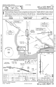
IAC chart of KEDE
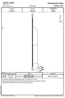
 ADC chart of KEDE
 Satellite view of KEDE
ADC chart of KEDE
Satellite view of KEDE
Sorry, we have no imagery here.
Sorry, we have no imagery here.
Sorry, we have no imagery here.
Sorry, we have no imagery here.
Sorry, we have no imagery here.
Sorry, we have no imagery here.


KEDE - Northeastern Rgnl
Located in Edenton, United States
ICAO - EDE, IATA - EDE
Data provided by AirmateGeneral information
Coordinates: N36°1'43" W76°34'11"
Elevation is 18 feet MSL.
Magnetic variation is -10° East View others Airports in North Carolina
Operational data
Special qualification required
Current time UTC:
Current local time:
Weather
METAR: KEDE 020950Z AUTO 10009KT 10SM CLR 12/09 A3030 RMK AO2 T01160092
Communications frequencies: [VIEW]
Runways:
| RWY identifier | QFU | Length (ft) | Width (ft) | Surface | LDA (ft) |
| 01 | 0° | 6001 | 100 | ASPH | |
| 19 | 180° | 6001 | 100 | ASPH |
Airport contact information
Address: Edenton United States
Satellite view of KEDE
Sorry, we have no imagery here.
Sorry, we have no imagery here.
Sorry, we have no imagery here.
Sorry, we have no imagery here.
Sorry, we have no imagery here.
Sorry, we have no imagery here.