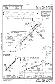
IAC chart of KEAU
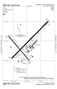
 ADC chart of KEAU
 Satellite view of KEAU
ADC chart of KEAU
Satellite view of KEAU
Sorry, we have no imagery here.
Sorry, we have no imagery here.
Sorry, we have no imagery here.
Sorry, we have no imagery here.
Sorry, we have no imagery here.
Sorry, we have no imagery here.


KEAU - Chippewa Valley Rgnl
Located in Eau Claire, United States
ICAO - EAU, IATA - EAU
Data provided by AirmateGeneral information
Coordinates: N44°51'57" W91°29'3"
Elevation is 913 feet MSL.
Magnetic variation is 01° East View others Airports in Wisconsin
Operational data
Special qualification required
Current time UTC:
Current local time:
Weather
METAR: KEAU 302256Z 30018G25KT 10SM CLR 25/09 A2978 RMK AO2 PK WND 30026/2208 SLP082 T02500094
TAF: KEAU 301720Z 3018/3118 30012KT P6SM BKN200 FM310100 29004KT P6SM BKN200 FM310900 VRB03KT 6SM FU BKN100
Communications frequencies: [VIEW]
Runways:
| RWY identifier | QFU | Length (ft) | Width (ft) | Surface | LDA (ft) |
| 04 | 45° | 8101 | 150 | CONC | 7701 |
| 22 | 225° | 8101 | 150 | CONC | 7301 |
| 14 | 139° | 5000 | 100 | OTHER | 5000 |
| 32 | 319° | 5000 | 100 | OTHER | 5000 |
Airport contact information
Address: Eau Claire United States
Other aviation service providers
Flight schools

Satellite view of KEAU
Sorry, we have no imagery here.
Sorry, we have no imagery here.
Sorry, we have no imagery here.
Sorry, we have no imagery here.
Sorry, we have no imagery here.
Sorry, we have no imagery here.