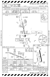
IAC chart of KDYS
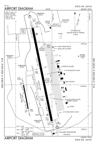
 ADC chart of KDYS
 Satellite view of KDYS
ADC chart of KDYS
Satellite view of KDYS
Sorry, we have no imagery here.
Sorry, we have no imagery here.
Sorry, we have no imagery here.
Sorry, we have no imagery here.
Sorry, we have no imagery here.
Sorry, we have no imagery here.


KDYS - Dyess Afb
Located in Abilene, United States
ICAO - DYS, IATA - DYS
Data provided by AirmateGeneral information
Coordinates: N32°25'7" W99°51'24"
Elevation is 1790 feet MSL.
Magnetic variation is 05° East View others Airports in Texas
Operational data
Special qualification required
Current time UTC:
Current local time:
Weather
METAR: KDYS 020755Z AUTO 17022G32KT 9SM CLR 25/19 A2939 RMK AO2 PK WND 18034/31 SLP923 T02450189 $
TAF: TAF AMD KDYS 020515Z 0205/0306 18020G30KT 9999 BKN100 QNH2942INS BECMG 0207/0208 23015G25KT 9999 FEW150 QNH2944INS BECMG 0209/0210 27012G18KT 9999 SCT100 QNH2945INS BECMG 0220/0221 24012G18KT 9999 SCT200 QNH2954INS BECMG 0300/0301 15012KT 9999 BKN130 QNH2954INS BECMG 0304/0305 10010G20KT 9999 OVC100 QNH2959INS TX26/0205Z TN20/0213Z LAST NO AMDS AFT 0205 NEXT 0211
Communications frequencies: [VIEW]
Runways:
| RWY identifier | QFU | Length (ft) | Width (ft) | Surface | LDA (ft) |
| 16 | 0° | 13500 | 300 | OTHER | |
| 34 | 0° | 13500 | 300 | OTHER | |
| 163 | 0° | 3500 | 60 | OTHER | |
| 343 | 0° | 3500 | 60 | OTHER | |
| 164 | 0° | 3498 | 60 | ASPH | |
| 344 | 0° | 3498 | 60 | ASPH |
Airport contact information
Address: Abilene United States
Satellite view of KDYS
Sorry, we have no imagery here.
Sorry, we have no imagery here.
Sorry, we have no imagery here.
Sorry, we have no imagery here.
Sorry, we have no imagery here.
Sorry, we have no imagery here.