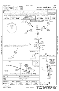
IAC chart of KDWH
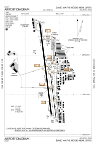
 ADC chart of KDWH
 Satellite view of KDWH
ADC chart of KDWH
Satellite view of KDWH
Sorry, we have no imagery here.
Sorry, we have no imagery here.
Sorry, we have no imagery here.
Sorry, we have no imagery here.
Sorry, we have no imagery here.
Sorry, we have no imagery here.


KDWH - David Wayne Hooks Meml
Located in Houston, United States
ICAO - DWH, IATA - DWH
Data provided by AirmateGeneral information
Coordinates: N30°3'42" W95°33'10"
Elevation is 152 feet MSL.
Magnetic variation is 05° East View others Airports in Texas
Operational data
Special qualification required
Current time UTC:
Current local time:
Weather
METAR: KDWH 021053Z AUTO 17008G20KT 9SM BKN020 OVC027 24/21 A2962 RMK AO2 PK WND 17026/1016 SLP028 T02440211
Communications frequencies: [VIEW]
Runways:
| RWY identifier | QFU | Length (ft) | Width (ft) | Surface | LDA (ft) |
| 17L | 173° | 3500 | 35 | ASPH | |
| 35R | 353° | 3500 | 35 | ASPH | |
| 17R | 173° | 7009 | 100 | ASPH | 6002 |
| 35L | 353° | 7009 | 100 | ASPH | 6700 |
| 17W | 0° | 2530 | 100 | WATER | |
| 35W | 0° | 2530 | 100 | WATER | |
| H1 | 0° | 0 | 0 | UNK | |
| H2 | 0° | 0 | 0 | UNK | |
| H3 | 0° | 0 | 0 | UNK | |
| H4 | 0° | 0 | 0 | UNK |
Airport contact information
Address: Houston United States
Other aviation service providers
Flight schools

Atp Flight School (800-All-Atps)
Atp Flight School (800-All-Atps)
info@atpflightschool.com+1(800)255-2877
Satellite view of KDWH
Sorry, we have no imagery here.
Sorry, we have no imagery here.
Sorry, we have no imagery here.
Sorry, we have no imagery here.
Sorry, we have no imagery here.
Sorry, we have no imagery here.