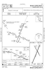
IAC chart of KDUX
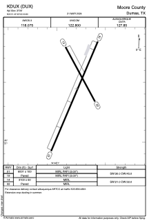
 ADC chart of KDUX
 Satellite view of KDUX
ADC chart of KDUX
Satellite view of KDUX
Sorry, we have no imagery here.
Sorry, we have no imagery here.
Sorry, we have no imagery here.
Sorry, we have no imagery here.
Sorry, we have no imagery here.
Sorry, we have no imagery here.


KDUX - Moore County
Located in Dumas, United States
ICAO - DUX, IATA -
Data provided by AirmateGeneral information
Coordinates: N35°51'27" W102°0'48"
Elevation is 3706 feet MSL.
Magnetic variation is 09° East View others Airports in Texas
Operational data
Special qualification required
Current time UTC:
Current local time:
Weather
METAR: KDUX 020235Z AUTO 20020G27KT 10SM BKN001 21/M03 A2931 RMK AO2 T02081027
Communications frequencies: [VIEW]
Runways:
| RWY identifier | QFU | Length (ft) | Width (ft) | Surface | LDA (ft) |
| 01 | 23° | 6001 | 100 | ASPH | |
| 19 | 203° | 6001 | 100 | ASPH | |
| 14 | 152° | 3100 | 60 | ASPH | |
| 32 | 332° | 3100 | 60 | ASPH |
Airport contact information
Address: Dumas United States
Satellite view of KDUX
Sorry, we have no imagery here.
Sorry, we have no imagery here.
Sorry, we have no imagery here.
Sorry, we have no imagery here.
Sorry, we have no imagery here.
Sorry, we have no imagery here.