IAC chart of KDTO
 ADC chart of KDTO
 Satellite view of KDTO
ADC chart of KDTO
Satellite view of KDTO
Sorry, we have no imagery here.
Sorry, we have no imagery here.
Sorry, we have no imagery here.
Sorry, we have no imagery here.
Sorry, we have no imagery here.
Sorry, we have no imagery here.


KDTO - Denton Enterprise
Located in Denton, United States
ICAO - DTO, IATA -
Data provided by AirmateGeneral information
Coordinates: N33°12'7" W97°11'57"
Elevation is 642 feet MSL.
Magnetic variation is 04° East View others Airports in Texas
Operational data
Special qualification required
Current time UTC:
Current local time:
Weather
METAR: KDTO 012153Z 16023G30KT 10SM FEW040 27/18 A2951 RMK AO2 PK WND 17034/2054 SLP986 T02670183
Communications frequencies: [VIEW]
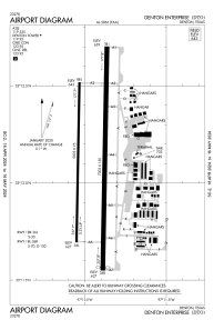
Runways:
| RWY identifier | QFU | Length (ft) | Width (ft) | Surface | LDA (ft) |
| 18L | 181° | 7002 | 150 | ASPH | 6502 |
| 36R | 1° | 7002 | 150 | ASPH | 6502 |
| 18R | 181° | 5003 | 75 | ASPH | |
| 36L | 1° | 5003 | 75 | ASPH |
Airport contact information
Address: Denton United States
Other aviation service providers
Repair station

Flight schools

Satellite view of KDTO
Sorry, we have no imagery here.
Sorry, we have no imagery here.
Sorry, we have no imagery here.
Sorry, we have no imagery here.
Sorry, we have no imagery here.
Sorry, we have no imagery here.