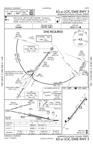
IAC chart of KDRO
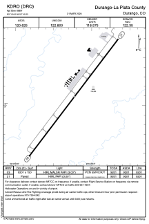
 ADC chart of KDRO
 Satellite view of KDRO
ADC chart of KDRO
Satellite view of KDRO
Sorry, we have no imagery here.
Sorry, we have no imagery here.
Sorry, we have no imagery here.
Sorry, we have no imagery here.
Sorry, we have no imagery here.
Sorry, we have no imagery here.


KDRO - Durango-La Plata County
Located in Durango, United States
ICAO - DRO, IATA - DRO
Data provided by AirmateGeneral information
Coordinates: N37°9'6" W107°45'14"
Elevation is 6689 feet MSL.
Magnetic variation is 10° East View others Airports in Colorado
Operational data
Special qualification required
Current time UTC:
Current local time:
Weather
TAF: KDRO 050538Z 0506/0606 VRB04KT P6SM VCSH SCT060 BKN100 FM051000 03008KT P6SM VCSH SCT025 OVC050 FM051800 24007KT P6SM OVC050 FM052100 27010KT P6SM VCSH OVC040 FM060200 VRB05KT P6SM VCSH OVC060
Communications frequencies: [VIEW]
Runways:
| RWY identifier | QFU | Length (ft) | Width (ft) | Surface | LDA (ft) |
| 03 | 37° | 9201 | 150 | ASPH | 9201 |
| 21 | 217° | 9201 | 150 | ASPH | 9201 |
Airport contact information
Address: Durango United States
Satellite view of KDRO
Sorry, we have no imagery here.
Sorry, we have no imagery here.
Sorry, we have no imagery here.
Sorry, we have no imagery here.
Sorry, we have no imagery here.
Sorry, we have no imagery here.