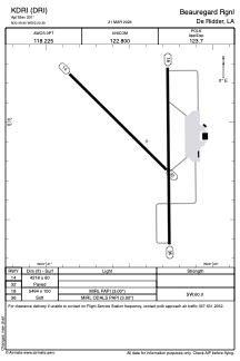


KDRI - Beauregard Rgnl
Located in De Ridder, United States
ICAO - DRI, IATA - DRI
Data provided by AirmateGeneral information
Coordinates: N30°49'54" W93°20'24"
Elevation is 201 feet MSL.
Magnetic variation is 04° East View others Airports in Louisiana
Operational data
Special qualification required
Current time UTC:
Current local time:
Weather
METAR: KDRI 021415Z AUTO 00000KT 10SM CLR 06/02 A3042 RMK AO2 T00610021
Communications frequencies: [VIEW]
Runways:
| RWY identifier | QFU | Length (ft) | Width (ft) | Surface | LDA (ft) |
| 14 | 134° | 4218 | 60 | ASPH | |
| 32 | 314° | 4218 | 60 | ASPH | |
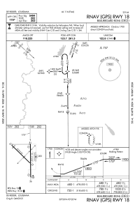
| 18 | 179° | 5494 | 100 | OTHER | |
| 36 | 359° | 5494 | 100 | OTHER |
Airport contact information
Address: De Ridder United States