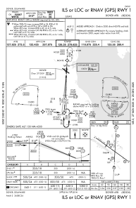
IAC chart of KDOV
 ADC chart of KDOV
 Satellite view of KDOV
ADC chart of KDOV
Satellite view of KDOV
Sorry, we have no imagery here.
Sorry, we have no imagery here.
Sorry, we have no imagery here.
Sorry, we have no imagery here.
Sorry, we have no imagery here.
Sorry, we have no imagery here.


KDOV - Dover Afb
Located in Dover, United States
ICAO - DOV, IATA - DOV
Data provided by AirmateGeneral information
Coordinates: N39°7'46" W75°27'57"
Elevation is 28 feet MSL.
Magnetic variation is -12° East View others Airports in Delaware
Operational data
Special qualification required
Current time UTC:
Current local time:
Weather
METAR: KDOV 241255Z AUTO 26015G20KT 10SM CLR 16/06 A3002 RMK AO2 SLP169 T01600064
TAF: TAF AMD KDOV 240804Z 2408/2514 27012KT 9999 FEW200 520104 QNH2997INS TEMPO 2408/2412 27012G21KT BECMG 2412/2413 27015G24KT 9999 FEW200 520104 QNH3003INS TEMPO 2413/2416 27021G30KT BECMG 2416/2417 30015G24KT 9999 SCT050 520104 QNH3002INS TEMPO 2417/2420 30021G30KT BECMG 2423/2424 30012KT 9999 FEW200 520104 QNH3007INS TX20/2418Z TN10/2410Z
Communications frequencies: [VIEW]
Runways:
| RWY identifier | QFU | Length (ft) | Width (ft) | Surface | LDA (ft) |
| 01 | 3° | 9602 | 150 | CONC | |
| 19 | 183° | 9602 | 150 | CONC | |
| 14 | 126° | 12903 | 150 | OTHER | |
| 32 | 306° | 12903 | 150 | OTHER |
Airport contact information
Address: Dover United States
Other aviation service providers
Flight schools

Satellite view of KDOV
Sorry, we have no imagery here.
Sorry, we have no imagery here.
Sorry, we have no imagery here.
Sorry, we have no imagery here.
Sorry, we have no imagery here.
Sorry, we have no imagery here.