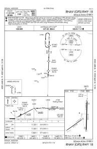
IAC chart of KDMO
 ADC chart of KDMO
 Satellite view of KDMO
ADC chart of KDMO
Satellite view of KDMO
Sorry, we have no imagery here.
Sorry, we have no imagery here.
Sorry, we have no imagery here.
Sorry, we have no imagery here.
Sorry, we have no imagery here.
Sorry, we have no imagery here.


KDMO - Sedalia Rgnl
Located in Sedalia, United States
ICAO - DMO, IATA - DMO
Data provided by AirmateGeneral information
Coordinates: N38°42'27" W93°10'33"
Elevation is 909 feet MSL.
Magnetic variation is 03° East View others Airports in Missouri
Operational data
Special qualification required
Current time UTC:
Current local time:
Weather
METAR: KDMO 051053Z AUTO 01006KT 7SM SCT012 06/04 A3013 RMK AO2 SLP207 T00560044
Communications frequencies: [VIEW]
Runways:
| RWY identifier | QFU | Length (ft) | Width (ft) | Surface | LDA (ft) |
| 05 | 54° | 3519 | 50 | ASPH | |
| 23 | 234° | 3519 | 50 | ASPH | |
| 18 | 182° | 5500 | 100 | CONC | |
| 36 | 2° | 5500 | 100 | CONC |
Airport contact information
Address: Sedalia United States
Satellite view of KDMO
Sorry, we have no imagery here.
Sorry, we have no imagery here.
Sorry, we have no imagery here.
Sorry, we have no imagery here.
Sorry, we have no imagery here.
Sorry, we have no imagery here.