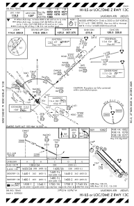
IAC chart of KDLF
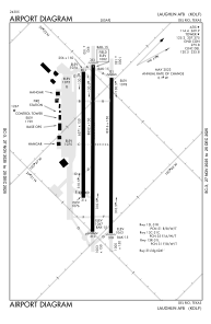
 ADC chart of KDLF
 Satellite view of KDLF
ADC chart of KDLF
Satellite view of KDLF
Sorry, we have no imagery here.
Sorry, we have no imagery here.
Sorry, we have no imagery here.
Sorry, we have no imagery here.
Sorry, we have no imagery here.
Sorry, we have no imagery here.


KDLF - Laughlin Afb
Located in Del Rio, United States
ICAO - DLF, IATA - DLF
Data provided by AirmateGeneral information
Coordinates: N29°21'34" W100°46'41"
Elevation is 1081 feet MSL.
Magnetic variation is 07° East View others Airports in Texas
Operational data
Special qualification required
Current time UTC:
Current local time:
Weather
METAR: KDLF 021155Z AUTO 11009KT 10SM OVC014 25/21 A2947 RMK AO2 SLP965 T02480209 10275 20248 53012 $
TAF: TAF KDLF 021000Z 0210/0316 12010KT 9999 BKN015 BKN250 QNH2944INS TEMPO 0212/0214 8000 BR BKN012 BECMG 0215/0216 VRB06KT 9999 FEW020 SCT250 QNH2948INS WND 13008KT AFT 0221 TX36/0222Z TN23/0212Z
Communications frequencies: [VIEW]
Runways:
| RWY identifier | QFU | Length (ft) | Width (ft) | Surface | LDA (ft) |
| 13C | 0° | 8852 | 150 | OTHER | |
| 31C | 0° | 8852 | 150 | OTHER | |
| 13L | 0° | 8316 | 150 | OTHER | |
| 31R | 0° | 8316 | 150 | OTHER | |
| 13R | 0° | 6571 | 150 | ASPH | |
| 31L | 0° | 6571 | 150 | ASPH |
Airport contact information
Address: Del Rio United States
Satellite view of KDLF
Sorry, we have no imagery here.
Sorry, we have no imagery here.
Sorry, we have no imagery here.
Sorry, we have no imagery here.
Sorry, we have no imagery here.
Sorry, we have no imagery here.