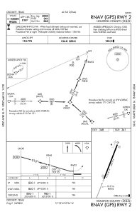
IAC chart of KDKR
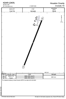
 ADC chart of KDKR
 Satellite view of KDKR
ADC chart of KDKR
Satellite view of KDKR
Sorry, we have no imagery here.
Sorry, we have no imagery here.
Sorry, we have no imagery here.
Sorry, we have no imagery here.
Sorry, we have no imagery here.
Sorry, we have no imagery here.


KDKR - Houston County
Located in Crockett, United States
ICAO - DKR, IATA -
Data provided by AirmateGeneral information
Coordinates: N31°18'25" W95°24'14"
Elevation is 348 feet MSL.
Magnetic variation is 05° East View others Airports in Texas
Operational data
Special qualification required
Current time UTC:
Current local time:
Weather
METAR: KDKR 021355Z AUTO 15013KT 9SM SCT019 SCT024 24/23 A2961 RMK AO2
Communications frequencies: [VIEW]
Runways:
| RWY identifier | QFU | Length (ft) | Width (ft) | Surface | LDA (ft) |
| 02 | 22° | 4000 | 75 | ASPH | |
| 20 | 202° | 4000 | 75 | ASPH |
Airport contact information
Address: Crockett United States
Satellite view of KDKR
Sorry, we have no imagery here.
Sorry, we have no imagery here.
Sorry, we have no imagery here.
Sorry, we have no imagery here.
Sorry, we have no imagery here.
Sorry, we have no imagery here.