


KDFI - Defiance Meml
Located in Defiance, United States
ICAO - DFI, IATA - DFI
Data provided by AirmateGeneral information
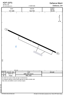
Coordinates: N41°20'15" W84°25'44"
Elevation is 706 feet MSL.
Magnetic variation is -05° East View others Airports in Ohio
Operational data
Special qualification required
Current time UTC:
Current local time:
Weather
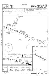
METAR: KDFI 221053Z AUTO 09004KT 10SM OVC036 M07/M11 A3047 RMK AO2 SLP331 T10721111
Communications frequencies: [VIEW]
Runways:
| RWY identifier | QFU | Length (ft) | Width (ft) | Surface | LDA (ft) |
| 12 | 115° | 4199 | 72 | ASPH | |
| 30 | 295° | 4199 | 72 | ASPH |
Airport contact information
Address: Defiance United States
