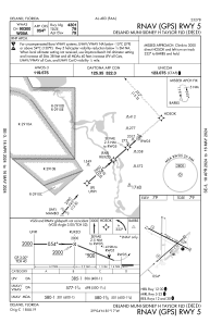
IAC chart of KDED
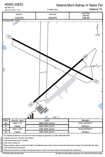
 ADC chart of KDED
 Satellite view of KDED
ADC chart of KDED
Satellite view of KDED
Sorry, we have no imagery here.
Sorry, we have no imagery here.
Sorry, we have no imagery here.
Sorry, we have no imagery here.
Sorry, we have no imagery here.
Sorry, we have no imagery here.


KDED - Deland Muni-Sidney H Taylor Fld
Located in Deland, United States
ICAO - DED, IATA -
Data provided by AirmateGeneral information
Coordinates: N29°4'1" W81°17'2"
Elevation is 79 feet MSL.
Magnetic variation is -05° East View others Airports in Florida
Operational data
Special qualification required
Current time UTC:
Current local time:
Weather
METAR: KDED 050715Z AUTO 11004KT 10SM CLR 19/18 A3019 RMK AO2 T01940183
Communications frequencies: [VIEW]
Runways:
| RWY identifier | QFU | Length (ft) | Width (ft) | Surface | LDA (ft) |
| 05 | 48° | 4301 | 75 | ASPH | |
| 23 | 228° | 4301 | 75 | ASPH | |
| 12 | 117° | 6001 | 100 | ASPH | |
| 30 | 297° | 6001 | 100 | ASPH |
Airport contact information
Address: Deland United States
Other aviation service providers
Flight schools

Avia Flight Academy International, Inc
Avia Flight Academy International, Inc
info@delandaviation.com+1(386)740-1955
Satellite view of KDED
Sorry, we have no imagery here.
Sorry, we have no imagery here.
Sorry, we have no imagery here.
Sorry, we have no imagery here.
Sorry, we have no imagery here.
Sorry, we have no imagery here.