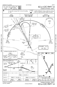
IAC chart of KDDC
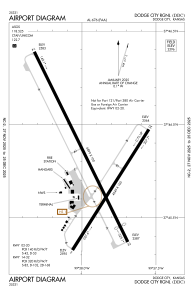
 ADC chart of KDDC
 Satellite view of KDDC
ADC chart of KDDC
Satellite view of KDDC
Sorry, we have no imagery here.
Sorry, we have no imagery here.
Sorry, we have no imagery here.
Sorry, we have no imagery here.
Sorry, we have no imagery here.
Sorry, we have no imagery here.


KDDC - Dodge City Rgnl
Located in Dodge City, United States
ICAO - DDC, IATA - DDC
Data provided by AirmateGeneral information
Coordinates: N37°45'47" W99°57'56"
Elevation is 2595 feet MSL.
Magnetic variation is 08° East View others Airports in Kansas
Operational data
Special qualification required
Current time UTC:
Current local time:
Weather
METAR: KDDC 111152Z AUTO 25003KT 9SM CLR 03/M04 A3032 RMK AO2 SLP261 T00331039 10089 20022 53005
TAF: KDDC 111120Z 1112/1212 31004KT P6SM SKC FM112000 18015G25KT P6SM SKC FM120800 17015KT P6SM FEW250 WS020/21040KT
Communications frequencies: [VIEW]
Runways:
| RWY identifier | QFU | Length (ft) | Width (ft) | Surface | LDA (ft) |
| 02 | 32° | 4649 | 100 | ASPH | 4649 |
| 20 | 212° | 4649 | 100 | ASPH | 4649 |
| 14 | 154° | 6899 | 100 | ASPH | 6329 |
| 32 | 334° | 6899 | 100 | ASPH | 6329 |
Airport contact information
Address: Dodge City United States
Other aviation service providers
Flight schools

Satellite view of KDDC
Sorry, we have no imagery here.
Sorry, we have no imagery here.
Sorry, we have no imagery here.
Sorry, we have no imagery here.
Sorry, we have no imagery here.
Sorry, we have no imagery here.