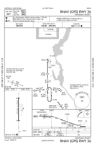
IAC chart of KDAF
 Satellite view of KDAF
Satellite view of KDAF
Sorry, we have no imagery here.
Sorry, we have no imagery here.
Sorry, we have no imagery here.
Sorry, we have no imagery here.
Sorry, we have no imagery here.
Sorry, we have no imagery here.


KDAF - Necedah
Located in Necedah, United States
ICAO - DAF, IATA -
Data provided by AirmateGeneral information
Coordinates: N44°2'0" W90°5'6"
Elevation is 919 feet MSL.
Magnetic variation is -01° East View others Airports in Wisconsin
Operational data
Special qualification required
Current time UTC:
Current local time:
Weather at : KVOK - Volk Fld ( 17 km )
METAR: KVOK 281955Z 32004KT 10SM FEW049 BKN070 15/12 A3011 RMK AO2A SLP201 T01470118
TAF: TAF KVOK 281700Z 2817/2923 01006KT 9000 -RA FEW035 SCT055 BKN060 QNH3010INS BECMG 2818/2820 01009KT 8000 -RA FEW035 SCT055 BKN060 QNH3008INS BECMG 2902/2904 35006KT 9999 -RA FEW035 SCT055 OVC065 QNH3000INS BECMG 2908/2910 34009KT 9999 NSW FEW035 SCT055 OVC070 QNH2996INS TX15/2916Z TN11/2910Z
Communications frequencies: [VIEW]
Runways:
| RWY identifier | QFU | Length (ft) | Width (ft) | Surface | LDA (ft) |
| 18 | 179° | 2721 | 60 | ASPH | |
| 36 | 359° | 2721 | 60 | ASPH |
Airport contact information
Address: Necedah United States
Satellite view of KDAF
Sorry, we have no imagery here.
Sorry, we have no imagery here.
Sorry, we have no imagery here.
Sorry, we have no imagery here.
Sorry, we have no imagery here.
Sorry, we have no imagery here.