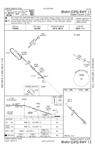
IAC chart of KCZT
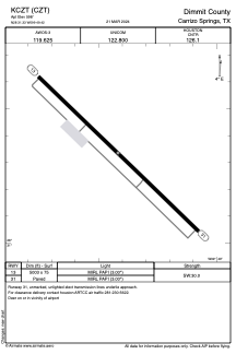
 ADC chart of KCZT
 Satellite view of KCZT
ADC chart of KCZT
Satellite view of KCZT
Sorry, we have no imagery here.
Sorry, we have no imagery here.
Sorry, we have no imagery here.
Sorry, we have no imagery here.
Sorry, we have no imagery here.
Sorry, we have no imagery here.


KCZT - Dimmit County
Located in Carrizo Springs, United States
ICAO - CZT, IATA - CZT
Data provided by AirmateGeneral information
Coordinates: N28°31'20" W99°49'25"
Elevation is 598 feet MSL.
Magnetic variation is 07° East View others Airports in Texas
Operational data
Special qualification required
Current time UTC:
Current local time:
Weather
METAR: KCZT 020035Z AUTO 15012G18KT 10SM 32/19 A2946 RMK AO2
Communications frequencies: [VIEW]
Runways:
| RWY identifier | QFU | Length (ft) | Width (ft) | Surface | LDA (ft) |
| 13 | 134° | 5003 | 75 | ASPH | |
| 31 | 314° | 5003 | 75 | ASPH |
Airport contact information
Address: Carrizo Springs United States
Satellite view of KCZT
Sorry, we have no imagery here.
Sorry, we have no imagery here.
Sorry, we have no imagery here.
Sorry, we have no imagery here.
Sorry, we have no imagery here.
Sorry, we have no imagery here.