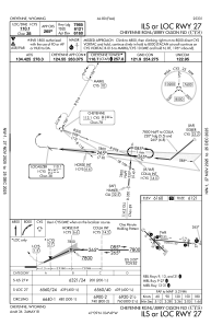
IAC chart of KCYS
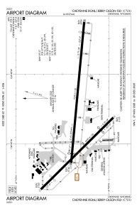
 ADC chart of KCYS
 Satellite view of KCYS
ADC chart of KCYS
Satellite view of KCYS
Sorry, we have no imagery here.
Sorry, we have no imagery here.
Sorry, we have no imagery here.
Sorry, we have no imagery here.
Sorry, we have no imagery here.
Sorry, we have no imagery here.


KCYS - Cheyenne Rgnl/Jerry Olson Fld
Located in Cheyenne, United States
ICAO - CYS, IATA - CYS
Data provided by AirmateGeneral information
Coordinates: N41°9'20" W104°48'38"
Elevation is 6159 feet MSL.
Magnetic variation is 10° East View others Airports in Wyoming
Operational data
Special qualification required
Current time UTC:
Current local time:
Weather
METAR: KCYS 070153Z 02009KT 10SM CLR 07/M08 A3009 RMK AO2 SLP188 T00721083
TAF: KCYS 062332Z 0700/0724 34012G20KT P6SM FEW250 FM070200 30008KT P6SM SKC FM071800 28012G20KT P6SM SKC
Communications frequencies: [VIEW]
Runways:
| RWY identifier | QFU | Length (ft) | Width (ft) | Surface | LDA (ft) |
| 09 | 95° | 9270 | 150 | CONC | 7985 |
| 27 | 275° | 9270 | 150 | CONC | 7985 |
| 13 | 135° | 6690 | 150 | ASPH | 4830 |
| 31 | 315° | 6690 | 150 | ASPH | 4880 |
Airport contact information
Address: Cheyenne United States
Other aviation service providers
Flight schools

Satellite view of KCYS
Sorry, we have no imagery here.
Sorry, we have no imagery here.
Sorry, we have no imagery here.
Sorry, we have no imagery here.
Sorry, we have no imagery here.
Sorry, we have no imagery here.