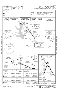
IAC chart of KCXO
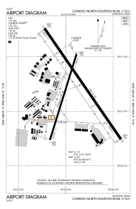
 ADC chart of KCXO
 Satellite view of KCXO
ADC chart of KCXO
Satellite view of KCXO
Sorry, we have no imagery here.
Sorry, we have no imagery here.
Sorry, we have no imagery here.
Sorry, we have no imagery here.
Sorry, we have no imagery here.
Sorry, we have no imagery here.


KCXO - Conroe/North Houston Rgnl
Located in Houston, United States
ICAO - CXO, IATA - CXO
Data provided by AirmateGeneral information
Coordinates: N30°21'12" W95°24'54"
Elevation is 244 feet MSL.
Magnetic variation is 05° East View others Airports in Texas
Operational data
Special qualification required
Current time UTC:
Current local time:
Weather
METAR: KCXO 012217Z 14010KT 10SM SCT015 BKN024 OVC050 26/22 A2967 RMK AO2 T02610222
TAF: KCXO 011721Z 0118/0218 17010G17KT 5SM HZ BKN016 OVC023 FM012000 15012G24KT P6SM BKN025 FM020400 15011G22KT P6SM BKN015 FM021500 18012G25KT P6SM BKN013
Communications frequencies: [VIEW]
Runways:
| RWY identifier | QFU | Length (ft) | Width (ft) | Surface | LDA (ft) |
| 01 | 17° | 5000 | 100 | CONC | 5000 |
| 19 | 197° | 5000 | 100 | CONC | 5000 |
| 14 | 145° | 7501 | 150 | CONC | |
| 32 | 325° | 7501 | 150 | CONC |
Airport contact information
Address: Houston United States
Other aviation service providers
Flight schools

Satellite view of KCXO
Sorry, we have no imagery here.
Sorry, we have no imagery here.
Sorry, we have no imagery here.
Sorry, we have no imagery here.
Sorry, we have no imagery here.
Sorry, we have no imagery here.