IAC chart of KCWI
 ADC chart of KCWI
 Satellite view of KCWI
ADC chart of KCWI
Satellite view of KCWI
Sorry, we have no imagery here.
Sorry, we have no imagery here.
Sorry, we have no imagery here.
Sorry, we have no imagery here.
Sorry, we have no imagery here.


KCWI - Clinton Muni
Located in Clinton, United States
ICAO - CWI, IATA - CWI
Data provided by AirmateGeneral information
Coordinates: N41°49'51" W90°19'44"
Elevation is 707 feet MSL.
Magnetic variation is 00° East View others Airports in Iowa
Operational data
Special qualification required
Current time UTC:
Current local time:
Weather
METAR: KCWI 022056Z AUTO 22020G28KT 10SM SCT022 22/16 A2933 RMK AO2 PK WND 21037/2001 SLP934 T02170161 56023
Communications frequencies: [VIEW]
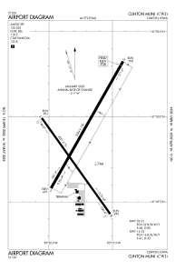
Runways:
| RWY identifier | QFU | Length (ft) | Width (ft) | Surface | LDA (ft) |
| 03 | 30° | 5204 | 100 | CONC | 5204 |
| 21 | 210° | 5204 | 100 | CONC | 5204 |
| 14 | 144° | 4201 | 75 | CONC | 4200 |
| 32 | 325° | 4201 | 75 | CONC | 4200 |
Airport contact information
Address: Clinton United States
Satellite view of KCWI
Sorry, we have no imagery here.
Sorry, we have no imagery here.
Sorry, we have no imagery here.
Sorry, we have no imagery here.
Sorry, we have no imagery here.