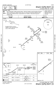
IAC chart of KCRT
 ADC chart of KCRT
 Satellite view of KCRT
ADC chart of KCRT
Satellite view of KCRT
Sorry, we have no imagery here.
Sorry, we have no imagery here.
Sorry, we have no imagery here.
Sorry, we have no imagery here.
Sorry, we have no imagery here.
Sorry, we have no imagery here.


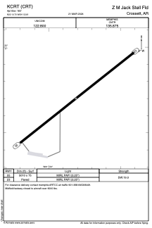
KCRT - Z M Jack Stell Fld
Located in Crossett, United States
ICAO - CRT, IATA - CRT
Data provided by AirmateGeneral information
Coordinates: N33°10'42" W91°52'49"
Elevation is 183 feet MSL.
Magnetic variation is 02° East View others Airports in Arkansas
Operational data
Special qualification required
Current time UTC:
Current local time:
Weather at : KBQP - Morehouse Meml ( 47 km )
METAR: KBQP 050455Z AUTO 16005KT 10SM BKN031 BKN039 OVC046 26/20 A2992 RMK AO2 T02600202
Communications frequencies: [VIEW]
Runways:
| RWY identifier | QFU | Length (ft) | Width (ft) | Surface | LDA (ft) |
| 05 | 52° | 5010 | 75 | ASPH | |
| 23 | 232° | 5010 | 75 | ASPH |
Airport contact information
Address: Crossett United States
Satellite view of KCRT
Sorry, we have no imagery here.
Sorry, we have no imagery here.
Sorry, we have no imagery here.
Sorry, we have no imagery here.
Sorry, we have no imagery here.
Sorry, we have no imagery here.